AVIATION
How Pilots navigate their Aircrafts in the Air?
The first GNSS used in aviation was NavStar GPS whereas in the present time the ICAO allows the use of both GPS and GLONASS in the aircraft.
Satellite Navigation in an Aircraft
Navigation is the key factor for successful operation of aircrafts. The aircraft uses the
navigation system from takeoff, climbing, en route, approach, and finally during taxiing
as well. People mostly get confused while talking about different navigation systems.
Global Navigation Satellite System (GNSS):
In general, GNSS encompasses all global satellite positioning systems. This includes
constellations of satellites orbiting over the earth’s surface and continuously transmitting
signals that enable users to determine their position. Some examples of GNSS are
⇸NavStar GPS (USA)
⇸Global Navigation Satellite System (GLONASS – Russia)
⇸Galileo (European Union)
⇸BeiDou (China)
Note: There are two regional systems of Japan and India known as QZSS and IRNSS
or NavIC respectively.
GNSS in Aviation:
The first GNSS used in aviation was NavStar GPS whereas in the present time the
ICAO allows the use of both GPS and GLONASS in the aircraft. Russia has already
replaced its navigation system to GLONASS from GPS. Regional navigation systems
like NavIC of India are mostly used by their military and fighter planes in their region.
Since the science behind all the navigation systems are much similar let’s discuss the
oldest and globally used system ; GPS.
Global Positioning System:
So basically GPS is the GNSS invented by USA’s department of defense consisting of a total 31 satellites constellation as per 2020 used globally for navigation, position and time determination. The GPS is used by the aviators throughout the world to increase
safety and efficiency of flight. The GPS satellite constellation is located at about 21000
km from the ground. Lifespan of each satellite ends after 7 years and is replaced by a
new satellite. In general a satellite is composed of Atomic clocks for precise timing,
power source or solar panels, attitude control system and transponding system.
The GPS includes three major parts called segments:
1.The satellite itself (Space segment): which includes the constellation of the
satellites.
2.Ground control segment: which includes a series of control stations at the
ground responsible to monitor orbits, synchronization of atomic clock and
possible failures of the satellite.
3.Receiver (User Segment): which indicates the position receiver of the user or
device(Navigation Display in an aircraft).
Working of GPS:
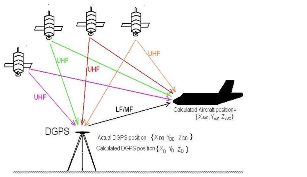
The basic working principle of GPS is called Trilateration which means a process
to determine absolute location of points by measuring distances with the help of
geometrical methods. GPS locators are present in an aircraft. The GPS sends a
signal to the required device and the time interval to reach the device is precisely
calculated by the atomic clocks and finally the time difference to reach the device
is multiplied by speed of light and the position is determined. This process is
done by more than one satellite and then the accurate position is determined.
For more accuracy the ground station sends signal to another satellite which
finally sends signal to the aircraft flying. The GPS helps in locating the aircraft’s
position easily and indicating the waypoints on the Navigation Display Screen.
To increase further precision a new technology known as differential GPS or
(D-GPS) is used which consists of a net of radio stations at ground that sends
local correction signals to the GPS receivers.
Advantages of having GPS:
● Continuous, reliable, and accurate positioning information for all phases of
flight on a global basis, freely available to all.
● Safe, flexible, and fuel-efficient routes for airspace service providers and
airspace users.
● Potential decommissioning and reduction of expensive ground based
navigation facilities, systems, and services.
● Increased safety for surface movement operations made possible by
situational awareness.
● Reduced aircraft delays due to increased capacity made possible through
reduced separation minimums and more efficient air traffic management,
particularly during inclement weather.